Beyond the well-trodden paths of popular tourist destinations lie some of the planet’s most extraordinary geological marvels. These hidden islands showcase nature’s incredible capacity for creating landscapes that defy conventional expectations, from volcanic formations that sculpt dramatic skylines to ancient coral structures that rise majestically from crystal-clear waters. Each remote archipelago tells a unique story written in stone, ice, and living coral across millions of years of geological evolution.
These forgotten paradises offer more than scenic beauty; they provide windows into Earth’s dynamic processes and evolutionary history. Whether shaped by volcanic activity, glacial movement, or marine erosion, these islands represent natural laboratories where you can witness geological phenomena rarely found elsewhere on our planet. Their isolation has preserved unique ecosystems and landforms that continue to captivate scientists and adventurous travellers alike.
Remote volcanic archipelagos and their geological formations
Volcanic islands represent some of the most dramatic examples of Earth’s creative power, where molten rock from deep within the planet emerges to form entirely new landscapes. These remote archipelagos showcase the incredible diversity of volcanic processes, from explosive crater formations to gentle shield volcano construction. The geological complexity found on these islands often results from multiple volcanic episodes spanning thousands or even millions of years.
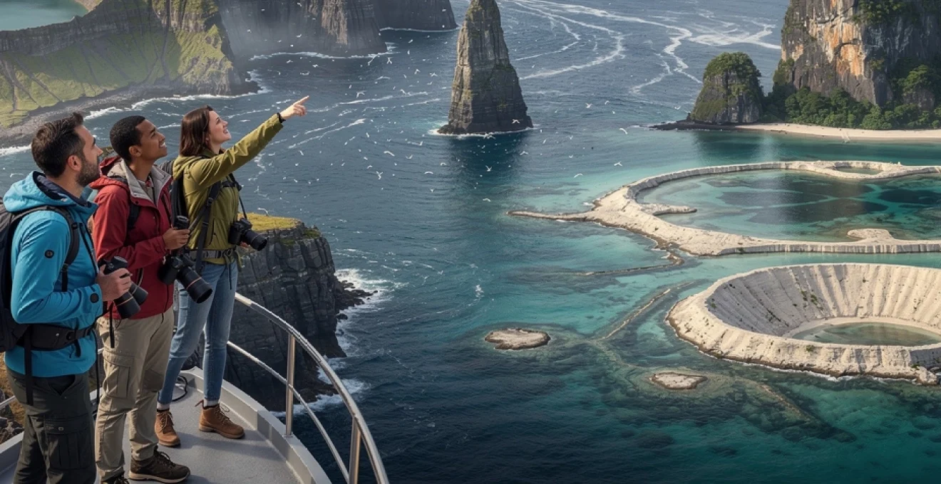
Azores’ caldeira das sete cidades: Twin-Lake crater systems
The Azores archipelago in the Atlantic Ocean contains one of the world’s most spectacular volcanic crater systems at Caldeira das Sete Cidades on São Miguel Island. This massive caldera, measuring approximately 12 kilometres in diameter, houses two distinct lakes separated by a narrow bridge of land. The Blue and Green Lakes derive their contrasting colours from differences in depth, mineral content, and algae populations, creating a natural phenomenon that appears almost artificially designed.
The formation of this twin-lake system occurred during a catastrophic volcanic eruption roughly 22,000 years ago, which created the circular depression now filled by these pristine waters. The surrounding crater walls rise dramatically to heights exceeding 500 metres, offering spectacular viewing platforms for observing this geological masterpiece. Local volcanic activity continues to influence the landscape, with numerous hot springs and fumaroles scattered throughout the caldera complex.
Socotra island’s dragon’s blood tree ecosystems
Socotra Island in the Arabian Sea presents one of Earth’s most alien landscapes, dominated by the iconic Dragon’s Blood Trees that have evolved in complete isolation for millions of years. These umbrella-shaped trees, scientifically known as Dracaena cinnabari, have adapted to the island’s arid conditions through unique morphological features including thick trunks for water storage and distinctive canopy structures that minimize water loss.
The island’s geological foundation consists of ancient granite and limestone formations that have been sculpted by wind and water into dramatic plateaus and deep canyons. Approximately one-third of Socotra’s plant species exist nowhere else on Earth, making it a living museum of evolutionary adaptation. The combination of geological isolation and climatic extremes has produced landscapes that appear more extraterrestrial than earthly, earning Socotra recognition as the “Galápagos of the Indian Ocean.”
Faroe islands’ basalt column formations and sea stacks
The Faroe Islands showcase some of the most impressive basalt column formations in the North Atlantic, created during massive volcanic eruptions approximately 55 million years ago. These hexagonal columns, formed through the slow cooling of lava flows, create geometric patterns that seem too perfect to be natural. The island of Vágar features particularly spectacular examples at locations like Gásadalur village, where the famous Múlafossur waterfall cascades directly from these columnar formations into the ocean.
The relentless Atlantic storms have carved these volcanic rocks into towering sea stacks and dramatic cliff faces that rise vertically from the ocean. Kallur lighthouse on Kalsoy Island sits atop knife-edge ridges formed by differential erosion of the layered basalt flows. These geological sculptures continue to evolve as wave action and weathering gradually reshape the coastlines, creating new formations while destroying others in an ongoing cycle of natural architecture.
Lord
Lord howe island’s volcanic remnant ball’s pyramid
Rising 562 metres almost sheer from the Tasman Sea, Ball’s Pyramid is the eroded core of an ancient shield volcano associated with Lord Howe Island in the southwest Pacific. This narrow triangular sea stack, just 1,100 metres long, represents the resistant volcanic dike material that remained after millions of years of marine erosion stripped away the original cone. Its near-vertical cliffs and knife-edge ridges make it one of the most extreme examples of a volcanic remnant anywhere on Earth.
For geologists and adventurous travellers, Ball’s Pyramid offers a rare opportunity to see the internal plumbing of a long-extinct volcano exposed above sea level. The surrounding seafloor drops rapidly to depths exceeding 1,000 metres, highlighting the immense original size of the volcanic edifice. Access is tightly controlled to protect fragile ecosystems, but regulated climbing expeditions and dive trips reveal a rich marine environment where pelagic species and colourful coral communities thrive around this dramatic geological monument.
Arctic and sub-antarctic islands with extreme topographical features
At Earth’s high latitudes, islands shaped by ice, permafrost, and ferocious winds present landscapes that feel almost otherworldly. Here, glaciation rather than volcanism is often the dominant architect, carving valleys, fjords, and isolated rocky outcrops that puncture vast ice fields. These Arctic and sub-Antarctic islands illustrate how cold-climate processes sculpt terrain in ways that differ radically from tropical or temperate regions.
Because access is challenging and seasons are short, many of these remote islands remain sparsely visited, serving as crucial reference points for understanding climate change and cryospheric dynamics. As you explore them (even virtually), you are looking at living laboratories where glaciers retreat, permafrost thaws, and new habitats emerge in real time. The stark beauty of these environments lies in the sharp contrasts between ice, rock, and ocean, and in the sense that the landscape is constantly in flux.
Svalbard’s permafrost-carved valley systems
The Svalbard archipelago, located midway between mainland Norway and the North Pole, is dominated by permafrost that reaches depths of several hundred metres. Repeated freeze–thaw cycles combined with glacial erosion have produced a network of U-shaped valleys and steep-sided cirques that dissect the mountainous terrain. These valleys often contain braided rivers and patterned ground features, where polygons and stone stripes reveal the slow but relentless action of frost heave on the surface sediments.
One of Svalbard’s most intriguing features is the presence of solifluction lobes, tongue-shaped accumulations of soil that slowly creep downslope as the active layer above the permafrost thaws each summer. For visitors hiking near Longyearbyen or Isfjorden, these lobes and terraces create a rippled appearance on valley flanks, a visible reminder that even apparently solid ground is on the move. Researchers monitor these landscapes closely, as increasing temperatures in the Arctic are accelerating permafrost thaw and altering slope stability, hydrology, and vegetation patterns.
South georgia’s glacial fjords and nunatak formations
South Georgia, a remote island in the South Atlantic, is renowned for its dramatic combination of steep mountains and deeply incised fjords reminiscent of a frozen Alps adrift at sea. More than half the island remains glaciated, and tidewater glaciers descend directly into narrow inlets such as Drygalski Fjord and Cumberland Bay. Over successive ice ages, powerful valley glaciers carved these fjords, exploiting lines of weakness in the bedrock to create over-deepened basins now filled by the ocean.
Scattered above the ice fields are nunataks, rocky peaks and ridges that protrude through the glacial surface like islands in a frozen sea. These nunataks serve as refuges for hardy plants and invertebrates that survived periods of maximum glaciation, making them crucial to understanding recolonisation after ice retreat. For travellers arriving by expedition ship, the juxtaposition of vertical rock walls, blue glacier fronts, and bustling penguin colonies offers one of the most striking examples of how glacial geomorphology and biology intertwine in sub-Antarctic environments.
Jan mayen’s beerenberg volcano and ice cap dynamics
Jan Mayen, a Norwegian island in the North Atlantic, is dominated by the active stratovolcano Beerenberg, which rises 2,277 metres above sea level and is capped by several outlet glaciers. Unlike many tropical volcanoes, Beerenberg’s flanks are heavily modified by glacial processes, creating a complex interplay between eruptive events and ice dynamics. Historical eruptions, most recently in 1985, have produced lava flows that interact with ice and snow, sometimes generating lahars and rapid meltwater floods that reshape lower slopes.
The ice cap itself behaves like a slow-moving conveyor belt, transporting snow and firn from high accumulation zones to lower ablation areas where crevasses, seracs, and ice cliffs form intricate patterns. As climate warming progresses, satellite data indicate thinning of some outlet glaciers, exposing more of the underlying volcanic edifice. For scientists, Jan Mayen is a natural observatory where they can study how volcanic heat and climate forcing together control the evolution of an ice-covered volcano—an important analogue for similar systems in Iceland and Antarctica.
Kerguelen islands’ wind-sculpted plateau landscapes
The Kerguelen Islands in the southern Indian Ocean, sometimes called the “Desolation Islands,” consist largely of basaltic plateaus uplifted and dissected by erosion over tens of millions of years. Constant exposure to the Roaring Forties and Furious Fifties—some of the strongest persistent winds on Earth—has carved these plateaus into a mosaic of mesas, buttes, and deeply incised valleys. The result is a landscape that feels like a high-latitude version of the American Southwest, but with tussock grass and peat in place of desert scrub.
Frost action, wind abrasion, and intense wave energy along the coasts have generated distinctive erosional forms, including sea arches, stacks, and wave-cut platforms that encircle many of the outer peninsulas. Inland, volcanic plugs and intrusive dikes stand out as resistant features, offering a glimpse of the plumbing beneath the once-active volcanic shield. For anyone fascinated by long-term landscape evolution, the Kerguelen Islands are a powerful reminder that wind and ice can be just as effective as lava in shaping island topography.
Tropical karst islands and underground cave networks
In warmer latitudes, some of the world’s most remarkable island landscapes have formed not from fire or ice but from the quiet dissolution of limestone. Tropical karst islands develop where thick carbonate platforms are uplifted or exposed, allowing rainwater and slightly acidic groundwater to carve sinkholes, towers, and extensive cave systems. Over geological time, this process can transform relatively level marine deposits into labyrinthine terrains that look like something from a fantasy novel.
These karst landscapes are more than surface spectacles; hidden beneath the jungle canopy and turquoise lagoons are underground rivers, cathedral-like caverns, and fragile speleothems that record past climate variations. As travellers, when we admire sheer limestone cliffs or paddle through sea caves, we are really seeing just the upper layer of an intricate three-dimensional puzzle. Careful management is essential here, since tourism pressure, pollution, and unregulated development can quickly damage the delicate hydrological networks that sustain both caves and coastal ecosystems.
Barrier reef atolls and coral geomorphology
Barrier reef atolls represent one of the most elegant examples of biological activity shaping large-scale geology. Originally formed around volcanic islands, these ring-shaped coral structures gradually persist even as their volcanic foundations subside, leaving behind encircling reefs and shallow lagoons. The resulting atolls are living records of sea-level change, tectonic subsidence, and coral growth over hundreds of thousands of years.
While many travellers associate atolls with idyllic beaches and overwater bungalows, their geomorphology tells a more nuanced story about resilience and vulnerability. Coral reefs are highly sensitive to ocean warming, acidification, and storm damage, which means the very structures that create these islands are under increasing stress. When you walk along a narrow motu or snorkel above a reef crest, you are literally standing on the accumulated skeletons of countless coral generations—and witnessing a dynamic equilibrium that climate change is starting to disrupt.
Aldabra atoll’s raised coral platform structure
Aldabra Atoll in the western Indian Ocean, part of the Seychelles, is one of the largest raised coral atolls in the world and a UNESCO World Heritage Site. Unlike many low-lying atolls, Aldabra’s main ring has been uplifted several metres above present sea level by tectonic forces, creating an elevated limestone platform dissected by channels and tidal inlets. This allows visitors to see ancient reef terraces and fossil corals high above the modern shoreline, offering a cross-section through past sea-level stands.
The inner lagoon, spanning roughly 225 square kilometres, experiences extreme tidal ranges that expose vast mudflats and intricate networks of channels at low tide. These conditions have fostered unique habitats for species such as the Aldabra giant tortoise, which roams across the pitted limestone known as karst pavements. For geoscientists, Aldabra serves as a natural archive of Quaternary sea-level change; for travellers, it is a rare chance to walk across what was once an actively growing reef crest now stranded in the air.
Christmas island’s phosphate mining terraces
Christmas Island in the eastern Indian Ocean is a limestone-capped volcanic seamount whose plateau has been extensively modified by phosphate mining for more than a century. The island’s original surface consisted of karstified terraces and sinkholes formed from uplifted coral reef deposits. Over time, the accumulation of bird guano on these porous limestones created rich phosphate layers, which were subsequently extracted, leaving behind stepped terraces and pits that give some slopes a distinctly artificial appearance.
This human-altered geomorphology sits alongside striking natural features such as sea cliffs, blowholes, and cave systems that penetrate the island’s rim. The contrast between untouched forested plateaus and mined landscapes provides a tangible example of how resource extraction can reshape island topography. Today, environmental restoration projects aim to stabilise spoil heaps and reforest mined areas, highlighting the challenge of balancing economic use with conservation on small, sensitive islands.
Bikini atoll’s nuclear test impact craters
Bikini Atoll in the Marshall Islands is infamous not for its pristine beauty, but for the series of nuclear tests conducted there by the United States between 1946 and 1958. These detonations fundamentally altered the atoll’s geomorphology, most notably through the creation of the Castle Bravo crater—an underwater cavity more than 1.8 kilometres wide and up to 75 metres deep. The explosion vaporised coral structures and lagoon sediments, leaving a scar that is still clearly visible on satellite imagery.
Paradoxically, decades after human evacuation, coral communities have begun recolonising many parts of the atoll, demonstrating a remarkable capacity for ecological recovery even in heavily disturbed environments. Yet the radioactive legacy persists in soils and some reef structures, and Bikini remains largely uninhabited. For those studying atoll dynamics, Bikini is a sobering case study in how sudden, high-energy events can overwrite thousands of years of gradual reef growth in a matter of seconds.
Palawan’s el nido limestone tower formations
The El Nido region of Palawan in the Philippines is famous for its dramatic karst tower landscapes, where razor-sharp limestone pinnacles and cliffs rise directly from jade-green lagoons. These towers are remnants of a thick carbonate platform that has been uplifted and then selectively dissolved by tropical rainfall and groundwater. Over millions of years, fractures and bedding planes in the limestone were widened into vertical shafts and caves, eventually isolating blocks of rock that now stand as freestanding towers.
For travellers kayaking through Bacuit Bay or hiking to hidden viewpoints, the sense of enclosure created by these vertical walls can feel almost cathedral-like, with light filtering down through narrow gaps. Beneath the surface, extensive cave networks and subterranean rivers continue the dissolution process, connecting inland karst with coastal inlets. Because the limestone here is highly fractured and sensitive to pollution, sustainable tourism practices—such as limiting boat numbers and managing wastewater—are essential to preserve both the spectacular scenery and the underlying hydrology.
Temperate maritime islands with unique erosional patterns
Between the tropics and the polar circles lie temperate maritime islands where wind, waves, and fluctuating sea levels have collaborated to create intricate erosional forms. Cliffed coasts, sea arches, and wave-cut platforms dominate many of these shorelines, providing textbook examples of how coastlines retreat under persistent attack from storm waves. Unlike tropical coral islands or glaciated Arctic archipelagos, these islands often show a patchwork of rock types, each weathering at different rates.
As you walk along their cliffs or pebbled bays, you can often trace the boundary between softer sedimentary rocks and harder igneous intrusions simply by the shape of the coast. Over time, headlands, coves, and stacks emerge in patterns that reveal the underlying geology as clearly as any map. For coastal managers contending with rising sea levels and more energetic storms, temperate maritime islands act as open-air laboratories for understanding long-term shoreline change and for testing nature-based solutions like managed retreat and dune restoration.
Desert islands and arid coastal formations
Not all islands are lush and tropical; some of the most striking landforms occur where arid climates intersect with volcanic or sedimentary foundations. Desert islands and dry coastal archipelagos showcase dune fields, salt pans, and stark lava flows that meet vividly coloured oceans. Here, limited vegetation cover exposes the raw structure of the landscape, allowing you to read the geological story much like you would scan the pages of an open book.
Because rainfall is scarce, wind becomes the dominant sculptor, moving sand into crescent-shaped dunes and polishing exposed rock surfaces. Occasional flash floods carve wadis and ephemeral channels that cut through coastal terraces before vanishing into the sea. In many of these environments, human settlement has historically been constrained by water availability, which means large areas remain relatively undisturbed, providing vital habitats for specialised flora and fauna that thrive under extreme conditions.
Galápagos’ lava tube networks and hornitos
The Galápagos Islands, straddling the equator in the eastern Pacific, are built almost entirely from basaltic lava flows, many of which have cooled to form extensive lava tube systems. As molten lava drained from beneath solidified crusts, it left behind tunnels that can extend for kilometres, some large enough to walk through comfortably. These tubes provide unique subterranean habitats and natural passageways that early settlers and modern hikers alike have used to traverse rough lava fields more easily.
Scattered across younger lava surfaces are hornitos, small spatter cones that form when gas-rich lava is forced through cracks in a crusted-over flow, building up chimney-like structures around the vent. These features, often resembling miniature volcanoes, offer a frozen snapshot of eruptive processes at a human scale. On islands like Santa Cruz and Isabela, guided tours into lava tubes and walks across pahoehoe and ʻaʻā flows allow visitors to experience first-hand how shield volcanoes construct new land inch by inch.
Canary islands’ laurisilva forest remnants
The Canary Islands off northwest Africa are best known for their volcanic peaks and black-sand beaches, but they also harbour remnants of ancient laurisilva cloud forests on islands such as La Gomera and La Palma. These evergreen broadleaf forests, thriving in cool, mist-laden conditions, once covered large parts of southern Europe during the Miocene. Today, they survive mainly on steep, north-facing slopes where trade winds deposit moisture, supporting lush vegetation amid otherwise arid volcanic terrain.
Geologically, the laurisilva zones occupy deeply incised ravines and amphitheatre-like valleys carved into old shield volcanoes. The contrast between bare cinder cones and densely forested barrancos illustrates how microclimate and topography interact to create pockets of extraordinary biodiversity. Hiking through Garajonay National Park, for example, you move from sun-baked ridge crests into moss-draped corridors where dripping water and thick leaf litter soften the harsh lines of the underlying basalt—like walking from one climatic epoch into another.
Cabo verde’s salt flat evaporation basins
The Cabo Verde archipelago off West Africa includes several islands where arid conditions and enclosed basins have produced striking salt flats. On Sal Island, the Pedra de Lume crater hosts a natural depression below sea level that has been flooded by seawater via subterranean channels. As intense sun and trade winds drive evaporation, salt crystallises across the basin floor, creating a brilliant white expanse that contrasts sharply with the surrounding dark volcanic slopes.
Historically, these salt pans were engineered into terraced evaporation basins, which amplified natural processes and supported an export industry for centuries. Today, some are still exploited, while others have become tourist attractions where visitors can float effortlessly in dense saline waters. The geomorphology here is a clear demonstration of how climate, geology, and human ingenuity combine to transform simple coastal depressions into highly productive—and visually arresting—desert landscapes.
Easter island’s moai quarry volcanic slopes
Easter Island (Rapa Nui) in the southeast Pacific is famed for its enigmatic moai statues, but the volcanic slopes from which they were carved are equally fascinating. The principal quarry at Rano Raraku occupies the flank of a tuff cone formed by explosive ash eruptions. The relatively soft, fine-grained volcanic tuff here was ideal for carving, and hundreds of partially finished or abandoned moai remain embedded in the hillsides, giving the impression that the mountain itself is sprouting stone figures.
Geomorphologically, Rano Raraku illustrates how human activity can become an integral part of a landscape’s evolution. Quarrying altered slope profiles, created cut faces, and exposed fresh rock surfaces to weathering, while subsequent erosion has gradually destabilised some statue-lined terraces. When you stand on the crater rim and look down at the freshwater lake within, it becomes clear that Rapa Nui’s iconic cultural heritage is inseparable from its volcanic origins—reminding us that on many islands, the line between natural and human-shaped landforms is far thinner than it first appears.